16 Unforgettable U.S. Waterfall Trails Every Hiker Needs to Experience
From easy forest walks to unforgettable backpacking adventures, these scenic waterfall hikes showcase some of America's most spectacular trails.
There's something irresistible about a trail that ends at a waterfall. You hear the rushing water before you see it, growing louder with every step until you round the final bend and a tumbling cascade comes into view. That build-up and anticipation are what set waterfall hikes apart, and they're why every trail on this list earned its spot.
From quick scenic trails to major bucket-list trips, these are the best waterfall hikes in the United States.
1. Kentucky: Eagle Falls Trail, Cumberland Falls State Resort Park
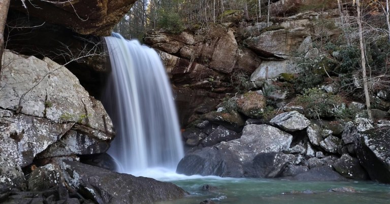
- Trail Snapshot: 1.8-mile round trip | Moderate (stairs, rocky sections, and rugged terrain) | Cliffside loop with river spur | Cumberland Falls State Resort Park, near Corbin | Best flow: winter through spring
- Need To Know: The trail can close during periods of high water on the Cumberland River. If you’re hoping to see a moonbow, check the park’s schedule first since viewing areas fill quickly on popular nights.
You get two very different waterfalls out of one short hike. Eagle Falls Trail starts along the bluff, where you can look across the river at Cumberland Falls. Known as the “Niagara of the South,” it's also the only place in the Western Hemisphere where you can regularly see a moonbow on clear nights around the full moon. From there, the trail drops over rocky ledges to Eagle Falls, a narrower 44-foot cascade tucked into a sandy alcove with a pool at its base. Bring a swimsuit if you want to take a dip after your hike.
2. Georgia: Amicalola Falls Stairs Trail, Amicalola Falls State Park

- Trail Snapshot: 2 miles round trip | Moderate (relentless steps) | Out-and-back stairs | Amicalola Falls State Park, Dawsonville | Best flow: winter through spring
- Need To Know: A $10 Georgia State ParkPass is required for all vehicles. The stair route is the classic way to experience the falls, but upper and lower viewpoints are also accessible by car.
At 729 feet, Amicalola is the third-highest cascading waterfall east of the Mississippi. More than 600 metal steps climb alongside the rushing water, bringing you close enough to catch the spray as you make your way up. Every turn reveals another section of the falls until you finally reach the top.
3. Hawaii: Pipiwai Trail to Waimoku Falls, Haleakalā National Park

- Trail Snapshot: 4 miles round trip | Moderate | Out-and-back with boardwalk sections | Kīpahulu District, Haleakalā National Park, Maui | Best flow: winter and spring rains, though it runs year-round
- Need To Know: Due to the winding Road to Hāna, visiting the Kīpahulu District requires a full day. Park entrance is $30 per vehicle, and swimming beneath Waimoku Falls is strictly prohibited due to the danger of falling rocks.
The Pipiwai Trail passes an overlook of Makahiku Falls, crosses boardwalks over stream gorges, and ducks beneath an enormous banyan tree before entering a bamboo forest so dense the light turns green, and the stalks knock together in the wind. On the other side, Waimoku Falls drops 400 feet down a sheer, moss-covered lava wall, easily making this one of the most beautiful waterfall hikes in America.
4. Alabama: Caney Creek Falls Trail, Bankhead National Forest

- Trail Snapshot: 2 miles round trip (about 4 miles if continuing to Lower Caney Creek Falls) | Moderate (steep canyon descent) | Out-and-back | Bankhead National Forest, near Double Springs | Best flow: late fall through spring, especially after rainfall
- Need To Know: Both parking options are on private property and require a cash donation: park at the County Road 2 lot ($5) and walk to the gated entrance, or use the private driveway lot ($20).
Bankhead is nicknamed the Land of a Thousand Waterfalls, and Caney Creek is one of the few where you can cool off at the end. The trail descends through hardwoods and hemlocks into a sandstone amphitheater where the falls spill about 20 feet into a deep pool. The rock behind the water is carved out far enough that you can walk in and look back through the falls.
5. California: Mist Trail To Vernal and Nevada Falls, Yosemite National Park

- Trail Snapshot: 2.4 miles round trip to the top of Vernal Fall; 5.4 miles round trip to Nevada Fall | Strenuous | Out-and-back or loop via the John Muir Trail | Yosemite National Park | Best flow: May and June snowmelt
- Need To Know: Sections of the Mist Trail and John Muir Trail may close because of snow, maintenance, or safety concerns. In 2026, trail repairs are causing temporary changes along both routes, so check Yosemite’s current conditions before visiting. A $35 vehicle entrance fee is required, and summer crowds can be heavy.
The climb to 317-foot Vernal Fall involves about 600 uneven granite steps, and during peak snowmelt, you’ll probably be soaked before reaching the top. Rainbows often appear in the mist, and hikers who continue farther are treated to 594-foot Nevada Fall before making their way back with views of both waterfalls.
6. Alaska: Thunderbird Falls Trail, Chugach State Park

- Trail Snapshot: 2 miles round trip | Easy | Out-and-back with viewing deck | Chugach State Park, near Eagle River | Best flow: late spring through early summer
- Need To Know: There is a $5 parking fee at the trailhead. The viewing area sits above a steep canyon, so use caution near the overlook, especially when winter ice can make conditions slick.
Less than half an hour from Anchorage, this easy waterfall hike follows the rim of the Eklutna River gorge through birch and spruce forest to a viewing deck overlooking 200-foot Thunderbird Falls. A short spur drops to the gravel bar below if you want to get closer. During the colder months, the waterfall freezes into a towering column of blue and white ice.
7. Pennsylvania: Falls Trail, Ricketts Glen State Park

- Trail Snapshot: 7.2-mile full loop (a 3.2-mile version hits the highlights) | Strenuous and slippery | Loop with significant stone-step elevation change | Ricketts Glen State Park, Benton | Best flow: spring and after fall rains
- Need To Know: The Falls Trail System is closed in winter except for properly equipped ice climbers and hikers. During warmer months, wet rocks and waterfall spray can make the stone steps slippery, so sturdy footwear with good traction is recommended.
Twenty-one waterfalls are packed into this single loop through the hemlock-filled ravines of Ricketts Glen. The trail follows Kitchen Creek past one cascade after another, with waterfalls tumbling over angled shale, plunging into rocky pools, and spilling beneath stone bridges. By October, the surrounding forest is glowing with shades of yellow, orange, and rust.
8. Idaho: Mesa Falls Nature Trail, Caribou-Targhee National Forest

- Trail Snapshot: About 2 miles roundtrip | Easy | Boardwalk and overlook network | Mesa Falls Scenic Byway, near Ashton | Best flow: late spring through early summer
- Need To Know: A $5 per-vehicle fee covers access to Upper Mesa Falls. The Mesa Falls Scenic Byway closes to cars in winter, and Upper Mesa Falls will temporarily close beginning Aug. 10, 2026, for renovations.
Upper Mesa Falls is the last major waterfall on the Snake River system that has never been dammed or diverted, so it runs at full force year-round. The Henrys Fork crashes 114 feet over a volcanic rim, and a series of boardwalks leads to overlooks that bring you surprisingly close to the water. It's a short walk with one of Idaho's biggest payoffs.
9. Arkansas: Hemmed-in Hollow Falls Trail, Buffalo National River

- Trail Snapshot: 5 to 6 miles round trip | Strenuous | Out-and-back with 1,400 feet of elevation change | Buffalo National River, near Compton | Best flow: winter through spring, or after heavy rain
- Need To Know: The waterfall’s flow can shrink significantly during drier summer months.
At 209 feet, Hemmed-in Hollow is the tallest waterfall between the Rockies and the Appalachians, hidden at the dead end of a deep Ozark canyon. Getting there means a steep descent through the forest and an even tougher climb back out. At the bottom, sheer bluffs surround a single ribbon of water that breaks into mist before reaching the rocks below.
10. Colorado: Bridal Veil Falls Trail, Telluride

- Trail Snapshot: 2.4 miles round trip (to base of falls) | Moderate (steady climb at altitude) | Out-and-back | Uncompahgre National Forest, Telluride | Best flow: late May through July snowmelt
- Need To Know: Parking is very limited at the Idarado Mine lot, especially during summer. The trail begins above 9,000 feet, so the short mileage can feel more demanding because of the elevation.
Bridal Veil Falls drops 365 feet from the cliffs above Telluride, making it the tallest free-falling waterfall in Colorado. The route climbs steadily through rugged mountain terrain, rewarding your effort with smaller cascades and sweeping San Juan Mountain views before delivering you right to the base of the falls. At the top sits a historic hydroelectric power plant perched right on the edge of the cliff.
11. New York: Gorge Trail, Watkins Glen State Park

- Trail Snapshot: 1.5 miles one way (3 round trip, or a $6 shuttle back) | Moderate (constant stairs) | Point-to-point gorge trail | Watkins Glen State Park, Finger Lakes | Best flow: spring through early summer; Gorge Trail closes seasonally in winter
- Need To Know: Watkins Glen State Park charges a $10 parking fee during the main season. The Gorge Trail typically closes from late fall through mid-May because of ice and winter conditions.
Nineteen waterfalls are packed into a one-and-a-half-mile walk through a narrow gorge carved into layers of shale and sandstone. More than 800 stone steps wind beneath bridges, through tunnels, and behind curtains of falling water as the canyon walls rise nearly 200 feet overhead. It feels less like a hike and more like walking through a natural cathedral carved by water.
12. Illinois: Trail to LaSalle Canyon, Starved Rock State Park

- Trail Snapshot: 4 miles round trip | Easy to moderate | Canyon and bluff trail | Starved Rock State Park, Oglesby | Best flow: spring, or within a day or two of heavy rain
- Need To Know: These rain-fed falls are best after recent rainfall and can disappear during dry periods. Starved Rock is undergoing trail improvements through 2026; expect some access changes during the project.
The trail follows wooded bluffs before dropping into one of Starved Rock's most scenic sandstone canyons. The waterfall spills from a ledge that juts out past the rock beneath it, leaving a dry gap underneath, so you can walk behind the falls and look back out into the canyon. In winter, the falls can freeze into dramatic columns of ice, transforming the canyon into one of the park’s most photographed scenes.
13. Oregon: Trail of Ten Falls, Silver Falls State Park

- Trail Snapshot: 7.2-mile loop (shorter variations possible) | Moderate | Canyon and rim loop | Silver Falls State Park, near Silverton | Best flow: November through May; excellent year-round
- Need To Know: A day-use parking permit is required at Silver Falls State Park ($10 for Oregon residents; $12 for out-of-state visitors), and dogs are not allowed on the Canyon Trail itself. Sections of the trail can temporarily close after storms or hazardous conditions; park alerts provide the latest information.
Few hikes can match this one: ten waterfalls on a single loop, four of them walk-behind. Trail of Ten Falls winds through old-growth forest and beneath towering basalt overhangs where centuries of rushing water have carved deep alcoves behind the falls. South Falls steals the spotlight, but the enormous cave behind North Falls is just as memorable.
14. Arizona: Havasu Falls Trail, Havasupai Reservation

- Trail Snapshot: 20 miles round trip (minimum) | Strenuous | Multi-day backpack | Havasupai Reservation, adjacent to Grand Canyon National Park | Best conditions: spring and fall; season runs February through November
- Need To Know: Havasu Falls requires an overnight permit from the Havasupai Tribe, and day hiking is not allowed. Permits cost $455 per person for a mandatory three-night stay and can be difficult to secure due to high demand. Flash flooding can lead to unexpected canyon closures.
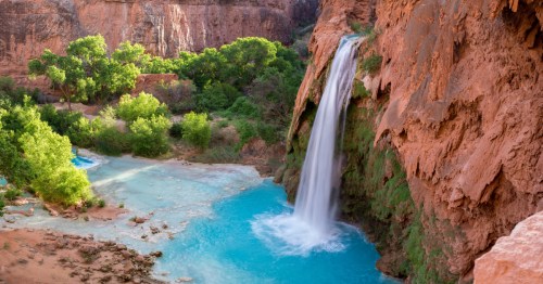
Everybody has this one on their list, and for once the hype holds. Havasu Falls sends water the color of a swimming pool 100 feet over red travertine cliffs into a side canyon of the Grand Canyon. To see it, you hike 10 miles across exposed desert, past Supai Village, to the campground, with Mooney and Beaver Falls farther downstream. This is an expedition, not a day trip, which is exactly why it stands out among bucket list waterfall hikes.
15. Indiana: Clifty Falls Trails, Clifty Falls State Park

- Trail Snapshot: 2 to 4+ miles depending on route | Moderate to rugged | Gorge-floor and rim trails | Clifty Falls State Park, Madison | Best flow: winter through spring
- Need To Know: A daily entrance fee applies ($7 for Indiana vehicles and $15 for out-of-state vehicles). The gorge trails can be rocky and wet, and some sections may close when conditions become unsafe.
Big Clifty, Little Clifty, Tunnel, and Hoffman: four waterfalls in one limestone gorge above the Ohio River. Trails run along the canyon floor and the cliffs above it, past rocky creek beds, fossil-filled formations, and overlooks. The terrain is steeper and wilder than most people expect from Indiana.
16. Connecticut: Kent Falls Steps Trail, Kent Falls State Park

- Trail Snapshot: 0.84-mile round trip | Easy to moderate (steep in spots) | Out-and-back | Kent Falls State Park, Kent | Best flow: spring, or after autumn rains
- Need To Know: Out-of-state vehicles pay a $15 weekend and holiday parking fee. Visitors can reach the falls via the ADA-accessible path or take the Steps Trail for a closer view of the cascades, while the red and yellow trails offer a longer loop option. Wading and swimming are prohibited.
Instead of one dramatic plunge, Kent Falls drops about 250 feet in a series of cascading steps down a wooded hillside. Wooden stairs climb beside the waterfall, with overlooks providing a different perspective at nearly every turn. The covered bridge near the base gives the waterfall that classic New England feel.
The Best Waterfall Hikes in the United States To Plan a Trip Around
Chasing the best waterfall hikes in the United States could keep you busy for a lifetime. From behind-the-falls canyons in Oregon and moonbows in Kentucky to turquoise desert pools in Arizona that require one of the country’s most coveted permits, these scenic trails prove there’s no single way to experience a great waterfall. Save the hikes that catch your eye, plan around seasonal flow, and remember the golden rule of waterfall travel: go after the rain, arrive before the crowds, and never trust wet rock. The sound of water through the trees will handle the rest.
Subscribe to our newsletter
Get the latest updates and news
Thank you for subscribing!