The Hoodoo Hike Most Wyoming Visitors Have Never Heard Of
Get up close and personal with some of Wyoming's coolest off-the-radar rock formations on this short and sweet interpretive trail that you've probably never heard of.
To those who only experience Wyoming from the highway, the Cowboy State has a whole lot of "nothing" to its credit. To be honest, if you've ever driven Interstate 80 between Rawlins and Rock Springs, there might be some truth to that sentiment. But those who live and love it here know that what Wyoming also has is a hefty dose of ancient geology—weird, wild, larger-than-life snapshots of ancient Earth physics in action both above and below the surface.
To put it another way, no matter which corner of the state you're exploring, Wyoming has a lot of rock doing strange but epic things: rhyolite geysers exploding like clockwork, volcanic pinnacles, eroded canyons, soaring peaks, rocks shaped like sunken ocean liners and eerie portals to nowhere, and thousands of otherworldly formations that flake and slump like drying clay. In between the big-name parks and scenic byways, there are countless places where Wyoming's landscape is slowly unraveling and rebuilding in fascinating ways over time. Gooseberry Badlands Recreation Area is one of them, yet few people have even heard of it, let alone visited.
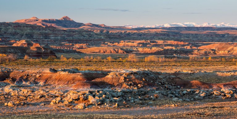
Wyoming is literally built from rock, and much of it is visible from the surface, as seen in many of the state's coolest formations and rock climbing areas. You also don’t have to travel far to find preserved remnants of ancient seabeds, river deltas, dune fields, or even ash from distant volcanic eruptions. The state’s exposed geology is fascinatingly diverse, spanning more than 2.5 billion years, and each layer is clearly shown in the state's many natural wonders. For this reason, Wyoming is one of the most studied places in North America due to its complete geologic record, from early life in the Precambrian to fossil mammals of the Cenozoic and everything in between. In fact, you've likely dug for a few fossils here over the years—or maybe even stumbled upon a few of them by chance out in the desert.
The 32-mile Red Gulch/Alkali National Backcountry Byway intersects this living geologic record, winding around the arid western edge of the Bighorn Mountains and merging with the dry heartland once roamed by dinosaurs and shaped by ancient seas. The sandstone and shale cliffs of the Triassic Chugwater Formation along the way frame the state's wide-open prairies and vast stretches of sagebrush steppe, occasionally giving way to reveal spectacular views of ancient, weather-carved rock formations in the distance. At first glance, these sights may not seem like much, with little more than the deep blue mirage-like outline of the Bighorns in the distance to admire. But head off the beaten path to look a little closer, and you'll be blown away.

About an hour off the main byway is hiding a quiet spot—and an even quieter trail—packed with prehistoric rock formations: Gooseberry Badlands. Badlands form where sediment erodes faster than vegetation can hold it in place. In Wyoming, they tend to show up in basins and river margins, carved into the soft clay and silt, like those found in Hell's Half Acre near Casper. Their colors, shapes, and sizes vary by region, but all of them offer a surprisingly clear look at the past. The Bighorn Basin is quite possibly one of the best areas to see this kind of landscape up close.

The Gooseberry Badlands, located about 15 miles west of Worland, is a compact, easily accessible area where early Eocene rock has been weathered into scenic hoodoos, pillars, gullies, and hills. The Willwood Formation exposed here was deposited an estimated 52 million years ago by low-flowing rivers and seasonal floodwaters. Today, these ancient sediments tell the story of a warm, semi-tropical environment now long gone.
From the parking area at the Gooseberry Badlands Scenic Overlook, a 1.5-mile loop trail drops down a gradual flight of stairs into the eroded basin. The path is maintained by the Bureau of Land Management and passes through shallow drainages and across a few wooden footbridges, circling back up along a low ridge with wide views of the stark formations below. Elevation gain is minimal, and the trail is easy to follow. The route also has a few benches and several interpretive signs placed along the way, but all you really need to enjoy this stroll is just the ability to wonder and marvel at Mother Nature's artistry.

The hoodoos at Gooseberry are all relatively short in stature if they were to be placed at eye level, but they're surprisingly dense in number and clearly formed. Geologically speaking, their makeup is no different than those found elsewhere: hard sandstone caps protect the softer claystone and mudstone below, creating narrow pillars as the surrounding material is washed or blown away. In some places, the hoodoos cluster close together in "groves." In others, they stand alone on benches and hillsides, leaning or undercut at the base. Unlike taller, similar formations seen in Utah or Colorado, the scale here makes them easy to examine closely without technical hiking (no climbing allowed).

There are a number of places to find hoodoos in Wyoming, often intermingled with various other rock formations. But those found at Gooseberry are a little extra special, especially when it comes to their color. Periods of history and proof of large-scale global events are almost perfectly preserved here, so the sediment layers in each hoodoo range from brick red to pale purple, cream, and light gray, with color differences tied to iron content and oxidation states. The redder layers are high in iron oxides and often indicate exposure to air and surface conditions during their formation. The gray and greenish bands suggest wetter environments, such as slow-moving rivers or shallow lakes. These color changes are visible throughout the hike and are most visible in early morning or late afternoon light.
The Gooseberry Badlands Interpretive Trail is an easy hike/stroll to admire this small scenic area, which sits within the larger 17,000-acre Bobcat Draw Badlands Wilderness Study Area, but only officially covers a few square miles. The trail’s high point is on the western side of the loop, where a short "climb" leads to an open ridge with long views across the Bighorn Basin. On clear days, you can see the Absaroka Range on the horizon to the west. To the south and east, the terrain flattens into rangeland, with scattered ranches and low hills typical of Eastern Wyoming.

Like most of Wyoming's rockiest areas, vegetation within the badlands is sparse. Big sagebrush shrubs, rabbitbrush, greasewood, and western wheatgrass cover much of the surface. In protected pockets and on higher ridges, you might find juniper or the occasional limber pine. Wildlife is limited during the heat of the day, but early morning hikers can spot mule deer, horned lizards, or raptors circling overhead. In terms of human company, though, the area is quiet and uncrowded on just about any given day.
Gooseberry Badlands is open year-round, and it's pretty neat to see the formations dusted with snow. The site is maintained by the BLM, and the road in is plowed in winter, although snowmelt and rain can make the clay trail muddy and difficult to walk. On the flip side, temperatures in July and August often soar into the high 90s and beyond, and there's little shade once you leave the trailhead. You'll definitely want to keep an eye out for rattlesnakes on your hike.
Worland and Meeteetse are the closest towns, and both offer basic services, accommodations, and historic storefronts. Thermopolis is 45 minutes east if you want to take a quick hot springs break or explore the Wyoming Dinosaur Center for more insight into Wyoming's ancient history. Either way, Gooseberry fits easily into a road trip through the Bighorn Basin or en route to Yellowstone’s east entrance.
For visitors interested in geology, earth history, or short, easy hikes with oodles of scenery, Gooseberry Badlands is worth a detour. This underrated stop packs a surprising amount of geologic detail into a small area, which makes it easy to see how time, climate, and erosion have shaped the surface of Wyoming, one hoodoo at a time. And if you can't get enough of the Cowboy State's rock formations, Adobe Town, Vedauwoo, the Red Wall, and so much more are just waiting to show off their own ancient secrets. Just pick a direction and start driving!
Subscribe to our newsletter
Get the latest updates and news
Thank you for subscribing!