Experience the Magic of Michigan’s Pictured Rocks National Lakeshore
Pictured Rocks National Lakeshore in Michigan offers stunning natural features and year-round outdoor activities.
The shores of Lake Superior are something to behold, with breathtaking scenery that changes with every mile. You can explore pristine lakeside beaches, naturally sculpted sandstone cliffs, and cascading waterfalls. It's land of inland lakes, deep forests, and a shoreline that's home to a variety of ecosystems. One of the greatest natural wonders in the United States, Pictured Rocks National Lakeshore in Michigan is the perfect destination for camping, hiking, or going for a weekend sightseeing excursion - and it is bound to impress you.
Getting to Pictured Rocks National Lakeshore
Pictured Rocks National Lakeshore is located in the Upper Peninsula of Michigan, making it a somewhat remote destination, but one that is absolutely worth the extra effort it takes to get here. There are no major airports, or even freeways, in the area - Detroit and Milwaukee would be the nearest - so driving is the best way to get there. The park is located approximately six hours from Detroit or Chicago, and just under five hours from Milwaukee. My drive to Pictured Rocks from my home in the Twin Cities (Minnesota) took a little less than seven hours.

History of Pictured Rocks National Lakeshore
Pictured Rocks gets its name from the uniquely colored sandstone cliffs - some of which tower more than 200 feet above a 15-mile stretch of Lake Superior coastline. In all, the park extends for 42 miles along the Lake Superior Shoreline of Michigan's Upper Peninsula, where sandstone cliffs have been exposed and sculpted by centuries of wind and water action. It is managed by the National Park Service and became the first of the nation’s three national lakeshores in 1996. (There were initially four, but Indiana Dunes was upgraded to national park status in 2019).
The unique colors of the cliffs come from the various minerals that have stained the sandstone in a veritable rainbow of hues, making for a sight unlike any other. In addition to these painted cliffs, the shoreline also features incredible arches, caves, and fascinating formations that are popular to explore by boat or kayak during the summertime and, when conditions permit, on foot during the snowy months.

“Is Pictured Rocks National Lakeshore worth visiting?”
Short answer? Definitely! Pictured Rocks National Lakeshore is open year-round and is stunning in every season.
Winter
The water beneath the park's cliffs and caves often freezes over during the winter, and when conditions are safe, you can hike to the ice caves for a truly surreal experience. The winter caves are formed by waves and water that has seeped through the porous sandstone and frozen, creating beautiful curtains of ice. If you're more adventurous - and skilled - you can even try your hand at ice climbing in the park.
In addition to these wondrous caves, ample snowfall creates excellent conditions for snowshoeing, cross-country skiing, and snowmobiling along the beautiful trails located throughout Pictured Rocks National Lakeshore.

Summer
Though winter is certainly an exciting season here, summer fun is equally as enticing - and really, summer is the best time to visit. During winter, large portions of the park are inaccessible, one visitor center is closed, and many ranger stations are unstaffed.
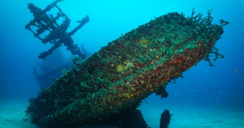
A favorite among hikers in the Midwest, Pictured Rocks is also a surprisingly popular scuba diving destination, especially for the shipwrecks caused by the rough waters of Lake Superior over the decades. The Alger Underwater Preserve, in particular, draws divers into the protected offshore areas hiding beneath the surface.
Another popular summer feature in Pictured Rocks National Lakeshore is the Grand Sable Dunes. The dunes cover more than five square miles and the tallest tower more than 300 feet above the lake, making them the highest formations in the park. While an impressive sight in their own right, the Grand Sable Dunes are also a unique ecosystem that is home to rare and endangered plant species. For those who prefer to sit back, relax, and take in the scenery, the beautiful beach at Sand Point is the perfect spot for it. The water here tends to be warmer for swimming than in other parts of the park, and it’s hard to beat a Lake Superior sunset.
Fall
Believe it or not, Pictured Rocks becomes even more stunning during autumn months. The bold hues of the fall foliage erupt in shades of red, orange, and gold, contrasting brilliantly against the pristine, blue water of Lake Superior.
Hiking at Pictured Rocks National Lakeshore
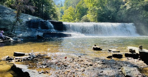
Above lake level, Pictured Rocks National Lakeshore is home to several of Michigan’s most beautiful waterfalls. Munising Falls is accessible from the Munising Falls Visitor Center via a short, paved trail. Miners Falls and Sable Falls are other popular options, tumbling 50 feet and 75 feet, respectively.

There is a short and sweet self-guided interpretive trail that ends at Miners Falls, but note that there are 77 steps leading down to the observation platform, so prepare for a bit of a climb on your way back up.
You'll find trails of all lengths and difficulty levels throughout Pictured Rocks National Lakeshore, ranging from paved walkways that are only a few hundred feet long to segments of the North Country Scenic Trail that stretch 42 miles through the length of the park. What there is not much of, however, is cell phone service. On my last visit, AllTrails Plus came in quite handy with its convenient, downloadable maps for offline use.
Exploring Pictured Rocks National Lakeshore
There are countless ways to explore Pictured Rocks on your own, but the National Park Service also offers fascinating guided tours where you can learn more about specific areas.

One popular ranger-led activity is the Lighthouse Tours of the Au Sable Lighthouse, which are offered from mid-June through the end of September. This active lighthouse is 87 feet tall and was built in 1874 to guide ships along Au Sable Point, one of the most dangerous areas of Lake Superior’s "shipwreck coast."
The park has two visitor centers, one on each end of the park. Munising Falls Visitor Center is located near the park's western end, while Grand Sable Visitor Center can be found near Grand Marais on the eastern end of the park. Several special programs and classes are offered at the visitor centers during the summer months for those who wish to learn more about the history and geology of the park.
No matter when you choose to explore Pictured Rocks National Lakeshore, you’ll be wowed in every season.

Between the beautiful views, unique natural features, and nearly endless activities available at Pictured Rocks National Lakeshore, it's clear that this is a true hidden gem along the nation's northern coast. Just don't forget a camera when you come to explore!
Where to Stay at Pictured Rocks National Lakeshore
Again, Pictured Rocks is pretty remote, so the lodging options in the park area are a tad slim. The park itself is home to three drive-in campgrounds and 14 backcountry campsites. You'll also find a handful of hotels and motels in Munising, the park's gateway community. There are many charming Airbnbs in the area, as well, like this sweet cabin near the shore of Lake Superior. You'll definitely want to book your lodging well in advance of your visit during peak times, as options tend to fill up.
Practical Tips for Visiting Pictured Rocks National Lakeshore
Accessibility
Although ice and snowy conditions can make parts of the park inaccessible during winter, Pictured Rocks administrators have worked hard to create an environment that is wheelchair accessible via several paved trails and overlooks, handicapped-accessible campsites, picnic sites, and beachside paved sidewalks. The Interagency Visitor Center, Munising Falls Interpretive Center, and Miners Castle Information Station in Munising, as well as the Grand Sable Visitor Center in Grand Marais, are all wheelchair-accessible. For more accessibility information, visit the official Pictured Rocks webpage.
Water Tours
Boat tours are available from Munising during the summer months. Kayaking is also a popular way to explore the shoreline. However, due to the potentially rough conditions on Lake Superior, guided kayak tours are highly suggested. Several authorized outfitters that will lead you to the most spectacular spots on the coastline can be found in Munising.
Pet Friendliness
Pets are allowed in certain areas of the park, but not all of them. Watch for signs. All pets must be on a six-foot leash at all times.
Seasonal Access
You can explore this park any time of the year, and there are activities for every season and type of outdoor adventurer. Some roads and access points may be closed during the winter. Visitor centers may be closed over major holidays.
Cost
Most park areas require fees. Standard entrance passes cost $15 to $25. Entry is free with an America the Beautiful Pass. Note: When I visited, I could not purchase an America the Beautiful Pass at the park, so I recommend picking up one ahead of your visit.
Feeling inspired to fill up your Bucket List? Check out our previous features of Red River Gorge in Kentucky, Big Bend National Park in Texas, and the beautiful Columbia River Gorge in the Pacific Northwest, then subscribe to our weekly Bucket List newsletter to discover new destinations across the country that definitely deserve a visit. And if that's still not enough adventure for you, give our Travel Planner a try!
Subscribe to our newsletter
Get the latest updates and news
Thank you for subscribing!