This Is the Least Visited Part of This National Park in Oregon
An overlooked piece of Oregon's tumultuous volcanic history is hiding in Crater Lake National Park, and it only takes a short hike to reach.
While western Oregon is known by many for its lush, green landscapes, breathtaking waterfalls, and scenic coastal beauty, southern Oregon is a region of transition — from the Cascade crest to the Klamath Basin, from dense conifer forests to dry, open volcanic plateaus. Highway 62 runs through it all, specifically connecting the agricultural town of Chiloquin, Oregon, to the timber country of Prospect and Union Creek. Between them sits Crater Lake National Park: a gorgeous slice of the Beaver State carved into the remains of Mount Mazama, an ancient volcano that once stood over 12,000 feet tall before collapsing in a violent eruption around 7,000 years ago. The blast spewed ash across eight states and completely reshaped the surrounding landscape. What remains today is a 33-mile-wide national park centered around the lake and encircled by dense forests and canyons.
But what you might not know is that the park is also hiding unique and untouched lava formations that rarely make it into local tourism guides.

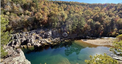
As Oregon's only full-fledged national park, Crater Lake National Park could easily be considered the state's crown jewel. This iconic blue lake is unfathomably deep (the deepest in the entire country at over 1,900 feet), wonderfully still, and is entirely contained within the caldera — the crater-like remnant formed by the volcano's collapse. It has no inlets or outlets and is only fed by snow and rain, which makes the water exceptionally clear. As a result of this ancient eruption, the lake is also bordered by cliffs up to 2,000 feet high, which create the perfect vantage point from which to admire the mirror-like beauty. Most visitors to the park stay near the rim, where accessible, paved overlooks show off panoramic views of the water, Wizard Island, and Phantom Ship. Or, Rim Drive loops the caldera, climbing and dropping along its edge, offering access to trailheads, viewpoints, and other pullouts that show off the stunning, jewel-toned water.
But southeast of the rim, away from the main loop and overlooks, is a less-visited section of the park where Crater Lake's volcanic origin story continues underground and resurfaces as stone. The Pinnacles Trail, located at the end of Pinnacles Road, shows off Crater Lake's fascinating volcanic history in the most unexpected way. Here, erosion has exposed a vertical field of volcanic vents — the solidified remains of gases that once escaped through deep ash deposits.
While Oregon's iconic lake shows the volcanic collapse, the underrated Pinnacles show the violent, geologic aftermath. Yet, despite being one of the coolest and most unique spots in the entire park, the Pinnacles Trail is surprisingly overlooked. But all it takes is a quick hike to enjoy incredible access to a concentrated display of volcanic processes rarely seen up close.

The trail is located in the southeastern corner of Crater Lake National Park, near the edge of the park boundary with Winema National Forest. As you turn onto Pinnacles Road, the landscape begins to shift away from the familiar waterfront setting as the dense subalpine forest that surrounds much of Crater Lake thins out. Here, tall, narrow, sparse lodgepole pines dominate the area. The ground turns pale — almost gray in places — still dusted with pumice and grit left over from the eruption of Mount Mazama. You’ll notice fewer cars and fewer people as the road runs gently downhill, tracing the outer flank of the caldera, away from the lake and toward the debris fields formed by the ancient eruption.
About halfway down the road, you'll begin to follow the upper reaches of Wheeler Creek, although you won’t see much water — just a deep, dusty channel cut into the surroundings. However, by the time you reach the trailhead, Wheeler Creek Canyon is the defining feature of the landscape. It’s a narrow, steep-walled canyon that is surprisingly deep given the low elevation, with portions of the canyon walls crumbling in places and scattered trees clinging precariously to the slopes.
Then, just as suddenly, before you've even reached the parking area, the Pinnacles appear — tall, jagged, tapering spires of volcanic rock rising from the canyon floor. These formations, known as fossil fumaroles, become more pronounced as you approach the end of the road.

From the trailhead found at the surprisingly roomy parking area, the Pinnacles Valley Trail offers an easy, out-and-back hike that brings you closer to these unique, towering geological features. It's a short and sweet jaunt at only two miles round trip, gently descending into Pinnacles Valley before looping around the rim near the formations. The trail is mostly well-maintained dirt with some rocky patches and is accessible for most hikers with decent fitness. Some parts may be a bit uneven or narrow near the edge of the valley, so watch your footing, especially if it’s wet or muddy. But fortunately, there are no major elevation changes or obstacles and only around 300 feet total of elevation change.

As you approach the Pinnacles on foot, the trail hugs the rim of the valley, providing vibrant, dramatic views down into the canyon where the spires stand like natural sculptures, each uniquely shaped and ranging from 30 to 100 feet in height. Look closely, and you can even see lava pockmarks and bubbles solidified in stone — evidence of the violent, molten happenings that caused the pinnacles to form. After the eruption of Mount Mazama, deep layers of pumice and ash were deposited across the region, and volcanic gases rose through the hot deposits. These gases vented upward, much like boiling water splashing over the edge of a soup pot, and over time, the heat and minerals cemented the ash into vertical columns of tougher rock. As Wheeler Creek gradually carved into the valley, it removed the softer material, exposing the solidified vents as tall spires of welded tuff and pumice.

Beyond the rock formations, the trail offers plenty of dramatic and diverse scenery. On clear days, you can look beyond the valley to see portions of Crater Lake’s rim and the surrounding Cascade peaks, including Mount Scott to the south. Early on, you’re hiking through a mixed forest of lodgepole pine, fir, and cedar, with plenty of undergrowth and occasional wildflower patches in the summer. The forested sections are cool and quiet — a classic Oregon mountain environment. Small wildlife are common and will keep you company the whole way (remember: don't feed the animals, no matter how cute they look!).
The Pinnacles Trail ends at a stone structure marking the park's eastern boundary. This site once served as the park's east entrance before the realignment of Highway 97 in 1956. Beyond this point, the trail briefly continues before intersecting with a set of forest service roads that lead into the Winema National Forest. This section is beyond the main action, although you're welcome to check it out so long as you follow existing signage.

Hiking the Pinnacles Trail only takes around one to two hours to complete, although you might find yourself spending some extra time admiring all the sights before enjoying a second helping of volcanic beauty on the way back. Along the way, you'll also encounter several short side trails that lead to the edge of the canyon, offering great opportunities to view the pinnacles from different angles. For your safety and for the protection of the landscape, stick with the established NPS routes.

Crater Lake might be the national park's main draw, but if you’re interested in geology or looking for a short hike away from the crowds, this easy trail is a hidden gem that's worth the extra drive. But if Oregon's volcanic history piques your curiosity, don't forget to check out Newberry Volcanic National Monument too!
Subscribe to our newsletter
Get the latest updates and news
Thank you for subscribing!