These 9 Hiking Trails In Idaho Are Completely Out Of This World
Idaho offers a variety of hiking trails ranging from easy family-friendly paths to challenging routes with stunning views and natural features.
When someone in Idaho tells you to take a hike, don't be offended! Hiking and backpacking are not only fantastic mood-boosters (it's true -- science says so!), but are also some of the best ways to get up close and personal with our beautiful state's scenic landscape and explore its hidden nooks and crannies. In fact, with over 19,000 miles of trails across the state, you never know what wildlife, edibles, or views you might discover! But no matter which trail you choose, the picturesque views are always well worth the climb.
Today, we've chosen nine must-try hikes of varying difficulties and terrains for you to tackle on your next outdoor adventure. Believe me, you won't regret it!
Sawtooth and Alpine Lakes, Stanley

A quaint and cozy town on the banks of the Salmon River, Stanley is well-known for its plethora of adventure and outdoorsman opportunities. This 10-mile can't-miss trek takes you to two of the Sawtooth's pristine alpine lakes, and will offer everything you could hope for in a hike.
From the Iron Creek trailhead off of Highway 21, you'll start in a forest of evergreens. You'll encounter an open meadow, cross a creek into an alpine basin, climb and meander through switchbacks before opening up to a scenic view of Mt.Regan. The whole trail is simply one of Idaho's most scenic, with impressive views of the mountains and valley.
Darby Wind Canyon, Driggs

Accessed from the Teton Valley in Eastern Idaho, Darby Canyon and the Darby Wind Cave offer spectacular views. You'll cross a quaint footbridge and ascend quickly through the lush trees of the Jedediah Smith Wilderness and colorful wildflowers, keeping to the right of the fork. Getting to the cave is a slippery climb that isn't recommended for novices, but you'll have plenty of scenery to check out without the dangerous scramble. Be warned: the combination of sheer cliffs and the ice cave crevice can create some unexpected and dangerous weather, so be prepared to turn back if ominous clouds roll in.
Drive south from Driggs on Highway 33. Three miles south of town, turn onto 3000 South, drive three miles more and make a right at the T-intersection. Follow the signs to the South Darby trailhead.
Upper Priest Lake Trail, Priest River

Scenic Priest River offers an abundance of trails for all skill levels. The 16-mile #308 is particularly scenic, running parallel to the river. Thick forest canopies provide plenty of shade with only occasional sun breaks, with the added relaxation of meandering streams running trailside. Continuing on to the Continental Trail will bring you to American Falls.
From Nordman, follow Highway 57 to the Granite Pass junction. Follow road #1013 approximately 11 miles to the trailhead on the left.
Upper Palisades Lake, Swan Valley

At over 15 miles, Upper Palisades Lake is slightly less used than the lower lake trail. A moose haven, this trail is beautiful with a variety of terrain to enjoy, and plenty of shade.
To reach the trailhead, from Swan Valley go seven miles east on US 26, then two miles northwest on Forest Road 255.
Mineral Ridge Loop, Coeur d'Alene

A quick and easy, well-maintained 2-mile trail that offers stunning views of Coeur d'Alene Lake, this hike has cliff views, switchbacks, and just enough challenge to make it worth it.
Take US-90 east from Coeur d'Alene for eight miles to Wolf Lodge Bay (exit 22), then go south on Highway 97 for three miles.
Hyndman Peak, Sun Valley

A massive, pyramid shaped mountain, Hyndman Peak is the 9th tallest in Idaho, but one of the easiest to climb, although the 12-mile ascent is lengthy. However, you'll be rewarded with immaculate views and very little fellow foot-traffic.
From Ketchum, drive five miles south on Highway 75 and turn onto East Fork Road. Drive six miles east (1.5 miles past Triumph), then make a hard left turn up a hill at the sign which says "North Fork of Hyndman Creek". Drive another three miles to the first stream crossing where Johnstone Creek and other creeks come together. Cross Hyndman Creek, then continue on the dirt road to the north side of the creek for 1.25 miles until you come to a road closure sign and gate. Park here.
Louie Lakes Loop, McCall

Louie Lake is a gorgeous deep-blue lake with the gray cliffs of Jughandle Mountain overlooking it. The lake contains two small granite islands, and the hike itself is a moderate 10-mile trek that offers expansive views of Long Valley.
About 2 miles south of McCall, turn east onto Elo Road. Elo Road becomes Farm-to-Market Road, which eventually becomes Brundage Lake Road. You will reach the trailhead at 7.5 miles.
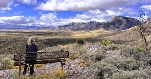
Owyhee Meanders, Owyhee Wilderness

Horrendous back-access roads and miles of desert landscape make the Owyhees far less of a destination retreat than its Northern Idaho counterparts. But for those who see beauty in the surreal, uninhabited landscape, the Owyhee Meanders make for an excellent hike. Late spring will offer an open expanse of colorful desert wildflowers. The scramble down the twisting, 500-foot canyon and into a marshy area known as the Tules will be unlike any hike you've ever experienced.
From Mountain Home, drive 93 mi. south on Highway 51 to an unmarked junction 0.7 mi. on the Nevada border. Turn right and follow the paved road for 6 miles, then turn left at the sign for the Owyhee River. Follow the gravel road 11 miles, stay straight, and drive 9 more miles until you've reached the parking area.
North Fork Big Creek, Challis

A challenging 29-mile semi loop will take you by waterfalls, Devils Basin, and sweeping open vistas of the Lost River Range, and to Yellow Lake, all following the North Fork Big Creek via Park Fork.
From Challis, take HIghway 93 north for 17 miles and take a right onto an unsigned road. In 30.5 miles, turn left onto Big Creek Rod to reach the trailhead in 3.5 miles.
Have you checked any of these trails off of your hiking bucket list? What did you think? Let us know what kind of hikes you would like to see next!
Subscribe to our newsletter
Get the latest updates and news
Thank you for subscribing!