The Epic 9-Mile Trail in Northern California That’s Worth the Sweat
Northern California is a confluence of wonders if there ever was one, and this 9-mile hike shows off some of its most majestic highlights.
California may not boast the 14ers of Colorado or the wild, soaring wilderness areas of Alaska, but it definitely has plenty to offer those looking for grandiose wonders and lofty heights. The Golden State's drama is especially obvious in its nine national parks, where you can trace ancient volcanic ridgelines in Lassen, explore coastal bluffs in Big Sur, and marvel at lush redwood canyons heavy with rainforest mist. Yosemite sits near the center of California's diverse beauty—almost perfectly halfway between Death Valley’s barren stretches in the south and the Lost Coast’s vibrant beaches in the far north. With 750,000 acres to explore and easy access to the Sierra Nevada, this is where California's soaring waterfalls and rugged peaks collide in a seriously monumental way. But for hikers who want epic views without the weight of a pack, the Panorama Trail is one of NorCal’s most rewarding one-day treks—so long as you're prepared for the challenge.

If you've ever marveled at the annual Firefall spectacle (every photographer's dream), swooned at the thought of climbing Half Dome, or gotten lost in the beauty of the park's Giant Sequoias, you know that Yosemite National Park is unmatched in terms of its larger-than-life sights. Threading between these natural wonders are countless trails that get up close and personal with many of them. But of all the hiking trails that NorCal has to offer, one must-do hike always seems to top the list: the 9.1-mile Panorama Trail in the heart of the park, which neatly ties some of the area's best highlights together. It cuts from Glacier Point to Yosemite Valley in a single, challenging trek, crossing creeks, hugging cliffs, and passing within reach of three of the national park’s most recognizable waterfalls. It's a lengthy full-day hike, but the cinematic, ever-changing views are worth the extra effort.
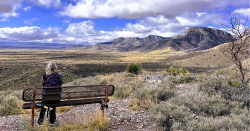
The Panorama Trail begins at Glacier Point (elevation 7,214 feet), near the southern rim of Yosemite Valley off Glacier Point Road. From this iconic overlook, Yosemite's beloved Half Dome stands front and center, towering above Tenaya Canyon. North Dome and Cloud’s Rest line the horizon to the east, and the Merced River flows through the deep gorge below.

It's a lot of drama to take in right from the get-go, so you'll definitely want to have your camera handy. In fact, it's so stunning you might not even feel the need to embark on a hike! But more panoramic views await below (hence the name of the trail), and you'll want to be prepared for some grueling ups and downs as you descend into the canyon to enjoy them.
The trail starts just south of the overlook near the amphitheater and is clearly marked. As soon as you set foot onto the path, it drops quickly into the forest and then onto an open rock slab with sweeping views west toward El Capitan and the Cathedral Rocks. In the first two miles, the trail continues to descend quickly through patches of lodgepole and fir before crossing Illilouette Creek on a narrow footbridge.

The largest of Yosemite's "hidden waterfalls," Illilouette Fall drops a dizzying 370 feet into an impossibly tight granite chute. While this massive cascade gets less attention than Yosemite’s more popular waterfalls, it’s the only one on the trail where you can cross directly above the plunge. Make sure you have a light jacket handy since you'll be encountering a lot of mist on this trail.
The crossing sits at roughly 6,400 feet, and the trail here flattens briefly before heading toward Panorama Cliff. Then, the climb out of the canyon begins immediately—the first of many—rising over 700 feet in a series of switchbacks that cut across exposed slopes. By the time you reach the ridge, Glacier Point is already well behind you. Fortunately, more views are unfolding ahead.

From Panorama Point, the trail descends steeply down toward Nevada Fall. Along the way, the trail to the 594-foot cascade drops through steep, uneven switchbacks that show off Half Dome’s majestic profile. At the river crossing above Nevada, the Panorama Trail merges with the Mist Trail and John Muir Trail. From here, the Mist Trail is a steeper trail that goes straight to the canyon floor, cutting past Vernal Fall on misty granite stairs. The John Muir Trail adds a few miles, but it avoids the wet rocks and steep staircases. Both routes offer endless views of both Vernal and Nevada Falls and rejoin near Happy Isles at the eastern end of Yosemite Valley. For experienced hikers, there's no right or wrong option, but keep in mind that the Mist Trail comes with a steep 2,000-plus foot elevation change, plus plenty of rocks, rock steps, and rugged terrain to navigate.

From start to finish, the Panorama Trail descends more than 3,200 vertical feet from its trailhead at Glacier Point. The landscapes shift constantly, from alpine forest to sunbaked granite, from narrow canyon paths to wide rock shelves. Since this point-to-point trail is a steep descent, boots with good traction are strongly recommended. However, if you're craving even more of a challenge, the Panorama Trail also forms the upper spine of a longer, even more ambitious route: the Panorama Loop. This 13-mile loop connects the Mist Trail, Panorama Trail, and the Four Mile Trail into one lengthy trail that adds a few extra viewpoints and another 1,000 feet of elevation change.
If you'd like to explore even further within the park, Yosemite’s massive trail system also offers other connections to the Panorama Trail. At the Illilouette Creek crossing, you have the option to head south toward Mono Meadow. At the top of Nevada Fall, hikers can break off toward Little Yosemite Valley and Half Dome (permit required), or continue on the John Muir Trail toward Yosemite's backcountry. Forks like these give the Panorama Trail plenty of choose-your-own-adventure flexibility.

While the Panorama Trail passes through some of the most photographed spots in the park, it's a surprisingly quiet hike between Glacier Point and Nevada Fall. Most of the crowds tend to be found at the endpoints: the overlook up top and the Mist Trail at the base. In between, the trail offers plenty of breathing room and epic, unobstructed views in all directions. Yes, the terrain is unforgiving in spots, and with such a steep descent, it's not a hike for novices. But as you stumble and slide your way down into the canyon (although, admittedly, you might be more sure-footed than I am), you'll have the opportunity to see and experience far more than many visitors take the time to. Altogether, depending on your experience and how often you stop to take photos, the hike down will take around six hours.
If you're wondering how to get back up to your starting point, you have a few options: book a ticket on the Glacier Point Tour Bus, use private shuttle services, or take the two-car approach (one parked up top, one parked at the base). No matter which option you choose, you'll want to have those travel logistics solidified before you attempt this hike because there's no camping, hammocking, or overnighting allowed along the trail. It's day-use only.
While you're in the park, there's plenty more to see, though! If you finish the hike early, still have energy, or have a flexible schedule, you've earned a reward. Walk or shuttle over to Curry Village (about a mile away) for a hot meal, some ice cream, or a spot to sit, rest, and recoup. If your legs still function, the visitor center and Ansel Adams Gallery in Yosemite Village are worth a quiet visit as well. You can even tackle the quick and easy Lower Yosemite Falls Trail, if you still have energy for a short walk.

The Panorama Trail isn't an easy hike, but if you only have one day here and are looking to experience a sample platter of the park's best overlooks, without the crowds, it’s definitely one of the best hikes in Yosemite. And what better way to experience the diversity of Northern California in all of its glory?
Planning a national park road trip this season? Use Only In Your State's AI Travel Planner to make the most of it!
Subscribe to our newsletter
Get the latest updates and news
Thank you for subscribing!