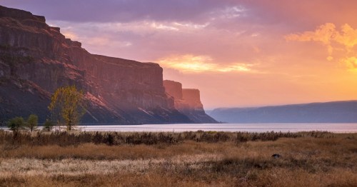
These 12 Beautiful Byways In Wyoming Are Perfect For A Scenic Drive
Discover the best scenic drives in Wyoming, offering breathtaking views and memorable adventures without the need for hiking.
Sometimes you just don't feel like hiking in order to see the natural beauty Wyoming has to offer. Well, you're in luck. Take the road less traveled, sit back, relax, and enjoy the view. The best scenic drives in Wyoming will take you on a truly memorable adventure.
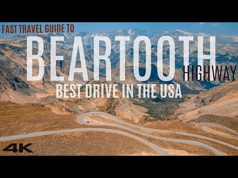
1. Beartooth Scenic Byway

Beartooth Scenic Byway is the only National Scenic Byway in Wyoming. Charles Kuralt described this byway as "the most beautiful drive in America." This two-lane route is the highest paved primary road in Wyoming. The Wyoming section of this drive is 47 miles or about a 1-hour drive and winds through Custer, Shoshone, and Gallatin National Forests and eventually leads up to the Northeast entrance of Yellowstone National Park.
The highest point of the drive is at Beartooth Pass. The scenery along the way includes mountain landscapes, glaciers, and alpine meadows. Beartooth Scenic Byway is listed on the National Register of Historic Places.
The Beartooth Scenic Byway is one of the most scenic drives near you in Wyoming and Montana. Learn more about it in this video from Alexyn Photo & Video:
2. Big Horn Scenic Byway

The Big Horn Scenic Byway is a 58-mile paved highway that runs along the crest of the Big Horn Mountains. It stretches from Powder River Basin to the Big Horn Basin. The scenery includes thick forests, meadows, waterfalls, and canyons. The most scenic part is on the western end which is where you will find Shell Creek Canyon and Shell Falls. This 1-hour drive follows US 14.
3. Bridger Valley Historic Byway

Bridger Valley Historic Byway is a 20-mile loop around noteworthy historical sites throughout Fort Bridger, Urie, Mountain View, and Lyman. It runs from Exit 34 on I-80 and then reconnects with the interstate at Exit 48. Take a glimpse back in time at the Bridger Valley Historic Byway.
4. Buffalo Bill Cody Scenic Byway

The Buffalo Bill Cody Scenic Byway starts west of Cody along the border of the Shoshone National Forest and follows the North Fork of the Shoshone River through the Wapiti Valley, then on to the East Entrance of Yellowstone National Park. The 27-mile paved highway, US 14/16/20, is a minimum of a 45-minute drive. This under-appreciated drive is truly a gem.
5. Centennial Scenic Byway

Centennial Scenic Byway stretches from Pinedale to Dubois. The byway is horseshoe-shaped and includes a combination of US 26/287 and US 26/89/191. During this drive, you will see badlands, ranch land, and mountainous ecosystems. If driven straight through, the 163-mile drive usually takes around 4 hours.
6. Chief Joseph Scenic Byway

Chief Joseph Scenic Byway is named after the Indigenous Chief of the Nez Perce Tribe. The byway links Cody with the Beartooth Highway and Yellowstone National Park by crossing the Shoshone National Forest through the Absaroka Mountains to Clarks Fork Valley and then on to the northeast entrance of Yellowstone National Park. This is a 47-mile paved byway that takes a minimum of 1 hour to drive. This is a wildly popular drive for a reason!
Check out another one of our favorite scenic driving roads in Wyoming, the Chief Joseph Scenic Byway, in this video from Decelerated Travel:
7. Cloud Peak Skyway Scenic Byway

Cloud Peak Skyway Scenic Byway is the southernmost route across Bighorn National Forest and into the Big Horn Mountains. This 47-mile stretch, also known as US 16, is a paved 2-lane highway that crests at Powder River Pass. The drive usually takes a minimum of 1 hour. This one may be our favorite.
8. Flaming Gorge - Green River Basin Scenic Byway

The Flaming Gorge-Green River Basin Scenic Byway runs along the border of Wyoming and Utah. The drive begins just west of Rock Springs and traverses through the high desert, rock formations, and mountain peaks. The 100-mile drive takes about 3 hours. You'll want to spend plenty of time exploring the area, too.
9. Snowy Range Scenic Byway

The Snowy Range Scenic Byway is located in the southern portion of Wyoming. The route crosses the Medicine Bow Mountain Range. If driving straight through, the drive takes about 1 hour. The scenery will make you want to get out and look!
10. Wind River Canyon Scenic Byway

The Wind River Canyon Scenic Byway begins in Shoshone at milepost 100, follows US 20N through Wind River Canyon and Wind River Reservation, and ends up north of Thermopolis at milepost 134. Along the way, you will notice the yellow and red rock of the Owl Creek Mountains, the Boysen Reservoir, rock walls, the Wind River, and maybe even some mountain sheep. The layers of rock are also marked with interpretive signage. Allow for about 40 minutes to take the drive. The Wind River Canyon is truly a wonder.
11. Star Valley Scenic Byway

Star Valley Scenic Byway is an 80-mile stretch of US 89 located in Lincoln County that passes through Salt Canyon, Salt River Pass and ends at the Lincoln County line in Snake River Canyon. The scenery along the way includes wilderness, rivers, wildlife, and snow-capped mountain peaks. Learn a little more about this whole valley region in Wyoming.
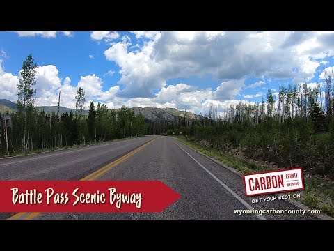
12. Battle Pass Scenic Byway

Battle Pass Scenic Byway is a 57-mile paved stretch of Highway 70 that runs westward from Encampment, through the Medicine Bow National Forest and crosses over the Sierra Madre Mountains where it drops into Savery, Dixon, and Baggs. The Byway was named after a battle fought between a group of fur trappers and Native Americans.
One of the best scenic drives in Wyoming is the Battle Pass Scenic Byway. Check it out in this video from Discover Carbon County, Wyoming:
For other scenic drives in Wyoming, check out these incredible Wyoming road trips to some of the most beautiful areas in the state. Make it an experience to remember by renting an RV from RVShare and taking a week to explore the open roads of Wyoming.
Subscribe to our newsletter
Get the latest updates and news
Thank you for subscribing!