
18 Best Hikes In Missouri: The Top-Rated Hiking Trails To Visit In 2023

Beth Price-Williams
Author
Hiking’s probably the best way to really get to know and appreciate all the natural beauty in Missouri. After all, we miss a lot when we’re in the car or even exploring by bike. The best hikes in Missouri take us deep into the forest, to big cities and small towns, and to ruins that we might never have known existed. Even better, we can go hiking in Missouri any time of the year.
Whether you’re a seasoned hiker or brand new to hiking, you’ll find plenty of hikes to meet your needs and interests. Here are just 18 of the best hikes in Missouri to help get you started.
Best Hikes in Missouri
We’re spoiled with choices when deciding where to hike in Missouri. More than 1,300 hiking trails wander throughout the state, ranging from easy to difficult. From chasing waterfalls to strolling past unique rock formations, we’ll find a little bit of everything. Here are just a few of the best places to hike in Missouri.

- Location: Ballwin, MO 63021
- Mileage: 3.4 miles
- Difficulty: Moderate
- FYI: The trail is popular with hikers and their pups. Because of some rocky terrain, you'll need sturdy hiking shoes.
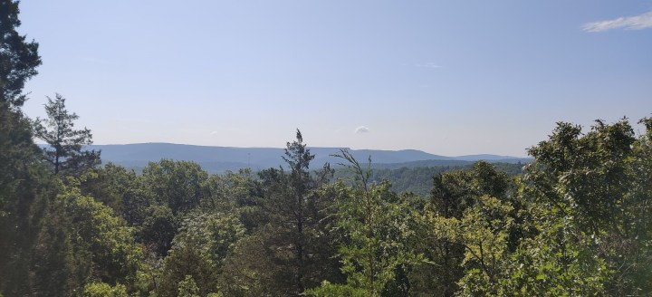
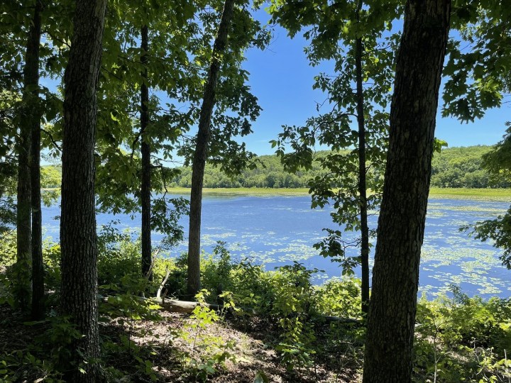
The more than three-mile River Scene Trail meanders through Castlewood State Park and earns a moderate rating due to rocky terrain and some steep climbs. Parts of the trail are quite narrow, making passing other hikers nearly impossible, so keep that in mind if you're in a time crunch. One of the highlights of this trail is the scenic overlooks and bluffs that promise sensational views of the Meramec River and beyond. Carve out at least 2.5 hours for your journey. Learn more about River Scene Trail on AllTrails.
- Location: St. Charles, MO 63304
- Mileage: 5.2 miles
- Difficulty: Easy/Moderate
- FYI: A popular dog-friendly trail. Winter's an ideal time to hike if you're looking for a bit of quiet when fewer hikers are on the trail.
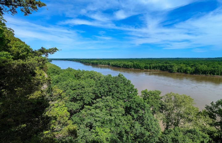
Follow the Lewis & Clark Trail, a five-mile jaunt that showcases some of the stunning natural beauty of Weldon Spring Conservation Area. Hikers consider the trail between easy and moderate, with some saying that it's also kid-friendly, so it really comes down to your experience as a hiker. The trail leads to wildflowers in the warmer months and offers breathtaking views of the Missouri River. Sturdy hiking shoes are a must as you'll deal with some rocky terrain, and downed trees are common. Learn more about one of the best hiking trails in Missouri on the official website of AllTrails.

- Location: Cedar Hill, MO 63016
- Mileage: 3.9 miles
- Difficulty: Moderate
- FYI: Sturdy shoes are an absolute must as you'll likely deal with downed trees. Mud is also common.
Journey along the Sandstone Canyon Trail, a nearly four-mile trail that boasts an abundance of natural beauty and several challenges along the way. In addition to keeping an eye out for downed trees, pay attention as you're hiking as there are several steep drop-offs along the pretty path. Your adventure will take you through a lush forest, past waterfalls, and sandstone canyons. The trail is kid-friendly and welcomes leashed dogs. View more information on the Sandstone Canyon Trail on the official website of AllTrails.
Best Short & Easy Hikes in Missouri
Short on time but really want to get outdoors, drink in the fresh air, and explore a bit? We’ve got you covered. You’ll find so many short, sweet, and easy trails in Missouri that your biggest challenge will be deciding which to follow first. May we suggest one of the following?

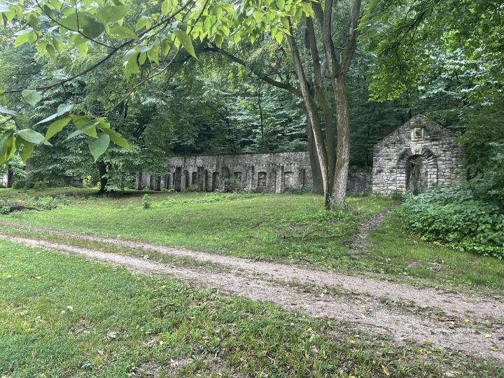
- Location: Camdenton, MO 65020
- Mileage: .08 of a mile
- Difficulty: Easy
- FYI: This wheelchair-friendly trail is open all year and is also suitable for kids and dogs on a leash.
Go on a magical stroll along the Castle Trail at Ha Ha Tonka State Park. The short and sweet trail, one of the best hiking trails in Missouri, leads to the ruins of Ha Ha Tonka Castle. An educational placard tells the story of these tragic ruins. You definitely don't want to forget your camera as a scenic overlook offers sensational views of the Lake of the Ozarks. Benches are placed along the trail, too, so you can stop, catch your breath, and admire your surroundings. Learn more about the picturesque Castle Trail on AllTrails.
- Location: Parkville, MO 64152
- Mileage: 2.6 miles
- Difficulty: Easy
- FYI: The short, sweet, and easy trail is kid-friendly and ADA-accessible. However, Parkville Nature Sanctuary does not allow dogs or bikes.
Bring the whole family along, including the little ones, for an adventure along the White Tail Trail. Clocking in at 2.6 miles, the scenic trail passes such beautiful scenery as waterfalls, brooks, and lush trees. You'll cross a footbridge or two on the trail that's well-shaded in the warmer months. The popular Missouri trail can get quite busy, and there's just a slight elevation of around 300 feet. Find more information on AllTrails.
- Location: Imperial, MO 63052
- Mileage: .06 of a mile
- Difficulty: Easy
- FYI: Dog-friendly and kid-friendly
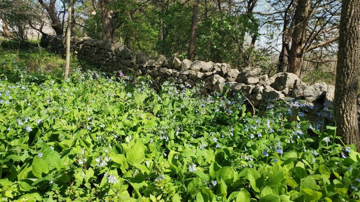
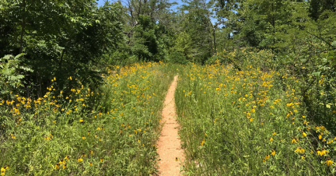
You won't need a lot of time to finish the Wildflower Trail that meanders through Mastodon State Historic Site. Carve out around half an hour to explore this path that's particularly pretty in the warmer months when the wildflowers are in full bloom. Despite its easy rating, the trail does have a few slight challenges, including elevation changes and stairs. Take it slowly if you're hiking after it rains or snows as the trail, as well as the stairs, can get quite slippery. You can also visit the Visitor Center, which features artifacts and fossils, before or after your hike. Learn more on AllTrails.
Hardest Hikes in Missouri
If you crave a challenge that will test your skills, you’ll find countless difficult hikes in Missouri. One of the best things about those hard hikes is the rewards – usually breathtaking views and a unique opportunity to connect with nature. The hardest hikes in Missouri certainly deserve a spot on your bucket list.
- Location: Arcadia, MO 63621
- Mileage: 17.6 miles
- Difficulty: Hard
- FYI: The dog-friendly trail is open all year.
Gear up for a mighty challenge along the 17.6-mile out-and-back Ozark Trail that will take you through Marble Creek Recreation Area in Mark Twain National Forest. Make sure you have sufficient supplies - water, food, bug spray, and sunscreen - before setting off. The trail generally takes around eight hours to complete. Be prepared for several challenges, including elevation changes and rocky terrain. As with any other hike, sturdy hiking shoes are a must, and some hikers recommend bringing poles along on this usually-quiet path. While you'll face quite a few challenges, you'll also be treated to such beauty as a waterfall, rock formations, and stunning views. Find more information on AllTrails.
- Location: Lesterville Township, MO 63654
- Mileage: 10.2 miles
- Difficulty: Hard
- FYI: This dog-friendly trail is popular with hikers and horseback riders. Pay attention to the sign at the entrance of the trail.
A moderate to difficult journey awaits on the Goggins Mountain Trail, a 10.2-mile trail that can usually be completed in half a day. If you feel like making an overnight of it, you can also backpack. The trail comes with quite a few challenges - steep grades, drop-offs, and water crossings. Keep an eye out for downed trees, roots jutting out of the ground, and loose rocks. If you're up for the challenge, you'll explore a lush forest, pass wildflowers, and enjoy breathtaking views of the mountain and nearby valleys. Check out more on AllTrails.

- Location: Bismarck, MO 63624
- Mileage: 9.4 miles
- Difficulty: Hard
- FYI: Sturdy boots are essential as the terrain along the trail is quite rocky. Leashed dogs are allowed.
If you like a good challenge, you'll certainly find it along the 9.4-mile Buford Mountain State Forest Trail. The trail's difficult rating is well-deserved as you'll face extremely rocky terrain, elevation changes, and loose gravel and rocks. Arm yourself with plenty of insect-repellant as it can get very buggy. Spiders and ticks are also abundant. The trail leads to the top of Bald Knob and some of the most spellbinding views in Missouri. View more photos on AllTrails.
Best Waterfront Hikes in Missouri
Missourians and water just go hand-in-hand, so naturally we’ve included some of the best waterfront hikes in Missouri. Each of these Missouri trails tallies less than five miles and promises sensational views of the water.

- Location: Valley Park, MO 63088
- Mileage: 3.2 miles
- Difficulty: Moderate
- FYI: Dogs and other pets are not allowed on the trail or in Lone Elk Park. However, you will likely see buffalo and elk during your visit.
The White Bison Trail has something for everyone - from colorful wildflowers to stunning views of the water. The highlight of the trail for many, however, is the chance to see the park's local residents, including elk, bison, deer, rabbits, turkey, and geese. View more photos on AllTrails.
- Location: Rolla, MO 65401
- Mileage: 4.7 miles
- Difficulty: Moderate
- FYI: The dog-friendly trail allows dogs to be off-leash in some areas. While the trail is marked, it can be tricky to follow.
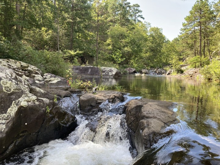
Hiking, mountain biking, and horseback riding are all popular ways to explore the 4.7-mile Crane Lake Trail, which winds through Mark Twain National Forest. Brimming with natural beauty, the hidden gem trail will lead you through a forest, past shut-ins, and to Crane Lake. Pack plenty of bug spray, and be prepared to deal with spider webs. There are a few creek crossings too, so you'll probably want to wear shoes you don't mind getting wet and even muddy. View more photos and learn more on AllTrails.
- Location: Kaiser, MO 65047
- Mileage: 2.2 miles
- Difficulty: Easy/Moderate
- FYI: The loop trail welcomes leashed dogs. Younger kids may have difficulty on this trail that's considered easy to moderate, depending on your experience and skills.
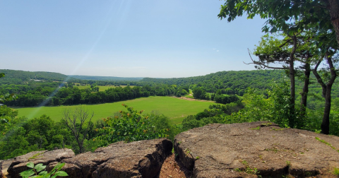
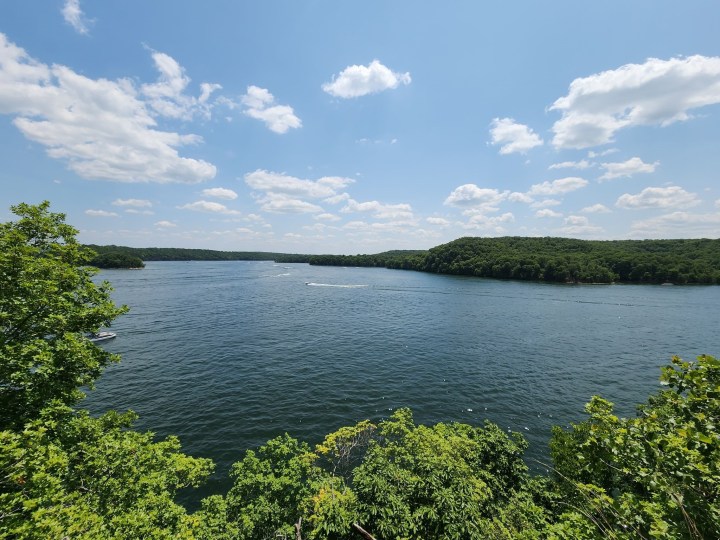
The highlight of the 2.2-mile Rocky Top Trail is, hands down, the stunning views of the Lake of the Ozarks that you'll enjoy along the way. Some hikers consider this one of the best hikes in Missouri and praise it for being well-marked. The majority of the trail is shaded, but you'll still want to bring plenty of sunscreen. Be prepared for some challenges - elevation changes, roots jutting out of the ground, and rocky terrain, too. However, it all evens out when you consider the natural beauty, from wildflowers to local wildlife, that will greet you along the trail. Find more information on AllTrails.
Best Winter Hikes in Missouri
Winter’s about more than curling up under the covers with a hot chocolate and watching the snow fall. It’s also the perfect time to get outdoors and go on a hike. Feel as though you’ve fallen into a snow globe when you follow the best winter hikes in Missouri. Bundle up!
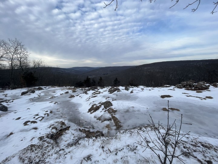
- Location: Ballwin, MO 63021
- Mileage: 1.7 miles
- Difficulty: Moderate
- FYI: Kid-friendly and welcomes leashed dogs.
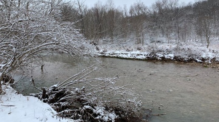
Walk through a virtual winter wonderland, especially after fresh snow, along the Lone Wolf Trail at Castlewood State Park. At just under two miles, the picturesque path does have a few challenges, especially in the winter, including loose rocks and roots jutting out of the ground. Snow can cover these hazards, so take care. The trail, which meanders along Kiefer Creek, starts with a fairly steep incline. Get more information on AllTrails.
- Location: New Offenburg, MO 63670
- Mileage: 2 miles
- Difficulty: Moderate
- FYI: Leashed dogs are allowed.
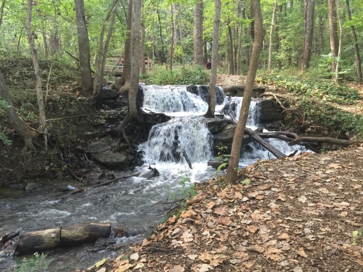
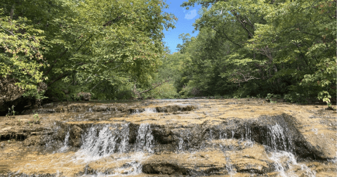
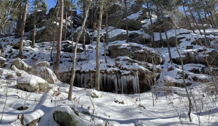
Meander past icy waterfalls on the Pickles Spring Natural Area Trail. While it's earned a moderate rating from All Trails, hikers also assert that it's kid-friendly. Just be prepared for uneven terrain and loose rocks that may be covered by snow. The pretty path passes such varied landscapes as box canyons, rock formations, and several waterfalls. Make sure you plan to hike it during the warmer months, too. Learn more on AllTrails.
- Location: Middle Brook, MO 63656
- Mileage: 2.9 miles
- Difficulty: Moderate
- FYI: A very popular trail with hikers. Leashed dogs are allowed.
Marvel at the tallest waterfall in Missouri when you follow the Mina Sauk Fall Trail, a spectacular cascade that's even more spellbinding capped in snow. Because of some rough terrain, the trail earns a moderate rating, although it's also considered kid-friendly. Mina Sauk Falls sits at about the halfway mark, so you can always hike to it and turn around if you're pressed for time. But the 132-foot waterfall isn't the only highlight of the trail, which also leads to the highest point in Missouri. Learn more on AllTrails.
Best Hikes Near St. Louis
Next time you’re in St. Louis, explore one of its short, sweet, and beautiful hiking trails. Each of the three hikes in Missouri featured below clocks in at under three miles and will take you to some of the most beloved destinations in St. Louis – from the Arch to Forest Park.

- Location: St. Louis, MO 63102
- Mileage: 1.8 miles
- Difficulty: Easy
- FYI: The trail is generally wheelchair and stroller accessible, although there are several small inclines that might pose a challenge.
The Jefferson National Expansion Memorial Trail promises beautiful views of Gateway Arch National Park and the Arch itself. At just under two miles, the path is kid and dog-friendly. Bring a picnic along and have a bite at one of the picnic tables. There are plenty of benches along the path, too. If you've got the time, you might even want to purchase tickets to go to the top of the Arch. Find more information on AllTrails.

- Location: St. Louis, MO 63112
- Mileage: 1.1-mile
- Difficulty: Easy
- FYI: Kid and dog-friendly path through St. Louis' famed Forest Park.
Go for a stroll along the short, sweet, and easy Picnic Island Loop Trail that showcases the beautiful Forest Park. Most describe it as a walk more than a hike, but you'll be treated to a ton of beauty - colorful flowers, a fountain, a suspension bridge, and an abundance of wildlife, including ducks. View more photos and plan your visit on AllTrails.
- Location: St. Louis, MO 63138
- Mileage: 2.7 miles
- Difficulty: Moderate
- FYI: This dog-friendly trail is popular with hikers, walkers, and runners.
Chances are pretty high that you'll run into other hikers along the Fort Belle Fontaine Loop Trail, an extremely popular trail that will lead you through the woods and to the remains of a historic trading fort. You can also walk up a grand staircase and, once at the top, capture some pretty stunning photos. Historical markers dot the path, offering insight into this fascinating site. Learn more on AllTrails.
These are just 18 of the best places to hike in Missouri. Did your favorite trails make the list of the best hikes in Missouri? Let us know in the comments! Then check out some of the best hiking trails in Missouri as recommended by you, our readers. Ready to explore even more of Missouri? Try AllTrails+ For Free
OnlyInYourState may earn compensation through affiliate links in this article. As an Amazon Associate, we earn from qualifying purchases.
More to Explore
Best Hikes In Missouri
Does Missouri have good hiking trails?
You'll find some of the best hiking trails in Missouri, including:
- Whispering Pines Trail meanders through Hawn State Park and provides quite a challenge, clocking in at more than 12 miles.
- Greer Spring Trail in Mark Twain National Forest leads to the second-largest spring in Missouri.
- The Interpretative Loop Trail at Grand Gulf State Park takes you to Missouri's very own Grand Canyon.
- See if you experience the paranormal along the Rock Hollow Trail which, thanks to its reputation for being haunted, is more commonly known as the Zombie Trail.
What are the best months to hike in Missouri?
One of the best things about hiking in Missouri is we can do it any time of the year. Spring and summer often mean passing vibrant wildflowers and lush foliage that, when fall arrives, will transform into jaw-dropping autumn colors. If you've ever wondered what a winter wonderland is like, just follow one of the best hikes in Missouri on a snowy day.